A culvert enables a stream, usually a small one, to pass under the canal. It is also used in low-lying places, where there is no stream, to drain water under the canal after wet spells.
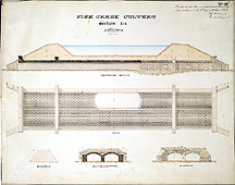
This culvert was located in the town of Ridgeway. The drawing at the top represents a longitudinal section looking down the path of the canal. The blue represents the water in the canal, the side berms are portrayed in yellow, and the culvert runs across the bottom from side to side. A buttress is placed for strength about a quarter of the way in from each side directly under each berm. An elevation, or side view of one of these buttresses is also shown in the middle drawing and in the center drawing at the bottom. The middle drawing is a plan of the culvert showing its double arches viewed from the top. The bottom right drawing is an elevation looking into the culvert from the side of the canal A variation on the basic culvert design is required when the water entering it is at a substantially higher level than the water exiting it.
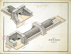
The culvert to the left was built near the town of Ridgeway. When water ran down a hill on one side of the canal, a cistern-like device was used to collect and drop the water down into the mouth of the culvert. In the lower figure, this device is drawn in cutaway and has a spillway on its left over which water would flow to enter the culvert. The top drawing shows the exit from the culvert. This stone structure was designed to be built on a double-planked wooden foundation, with sheet piling at each end of the culvert to prevent rushing water from undermining the structure.
Additional Information:
Just the right amount of water in the Canal, not too much nor too little, was very difficult and frequently impossible to maintain. Too much water would undermine banks and too little would limit the cargo that the boats could take on. Streams flowing toward the canal had to be channeled into culverts to flow under the canal and out the other side. As the land around the canal was timbered and farmed, runoff into the streams after storms increased and the culverts had to be reinforced, redesigned, or replaced as they failed. At the same time, to compensate for evaporation and the downstream flow of water, the water constantly needed to be replenished to maintain the required levels. Because the canal was above the water table, leakage through the banks was another major cause of water loss.
To adjust to the local conditions, each lock and each aqueduct required a unique design. Because there was little or no data on annual rainfall and fluctuations in stream flow, culverts were frequently inadequate. With an average of one stream encountered per mile, culvert repair and replacement was on-going. Because the culverts were just a few feet below the canal, to increase their carrying capacity it was necessary to broaden the culvert with additional arches rather than enlarge the diameter of the culvert.
http://www.eriecanal.org/UnionCollege/The_Culvert.html